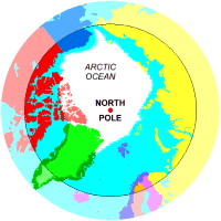
MAPS OF THE ARCTIC AREA (Athropolis)
The Athropolis Arctic Map Series with information pop-up boxes and daily weather reports for Arctic locations.
BIG Map of the Arctic (with weather reports)
Map of the Arctic defined by the Arctic Circle
Map of the Arctic defined by Temperature
Map of the Arctic defined by the Treeline
Map of Arctic Explorers' Routes
Maps of the Northwest Passage
Map of Nunavut
Source of North Atlantic Icebergs
Map of Cold Places and Cold Winds
ARCTIC LIBRARY
Want to know more about the Arctic? There's just about everything in this library that you'd ever need to know, listed both ALPHABETICALLY and by CATEGORY - with lots of maps to support the information (see below). Ideal for students (double-click any word on these pages for a "pop-up" definition.)
ARCTIC LIBRARY MAPS: Countries with land or territories within the Arctic Circle.
Alaska (USA),
Canada,
Finland,
Greenland (Denmark),
Iceland,
Norway,
Russia,
Sweden
ATHROPOLIS ARCTIC LIBRARY PAGES WITH MAPS:
A
Alaska,
Arctic National Wildlife Refuge,
Arctic Convoy,
Arctic Ocean,
Arctic Ocean Currents,
Arctic Winds,
Askja Volcano ,
Auroral Ring/Oval
B
Baker, Mt.,
Beaufort Gyre,
Bering Land Bridge,
Bering Strait
C
Canada
D
Davis, John
E
Erebus & Terror
F
Finland,
Franklin Search
G
Geographic North Pole,
Geomagnetic Pole,
Great Circle Route,
Great Ocean Conveyor Belt,
Greenland,
Greenland Shark,
Gyrfalcons
H
HMS Resolute
I
Iceland,
Iceland Volcanoes,
Ice Age,
Ice Age Globe,
Ice Challenger,
Ice Circulation Systems,
Iceberg Alley,
Iceberg Drifting,
Iceberg Source,
Iditarod,
Isotherm
L
Lapland,
Longitude
M
Magnetic Field,
Magnetosphere,
Mid Atlantic Range,
Mount Baker,
Murmansk,
Mythical Arctic
N
Nautilus,
Norrland,
North Magnetic Pole,
Northern Sea Route,
Norway
O
Ocean Currents
P
Polar Bear Territories,
R
Resolute, HMS,
Russia
S
Seasonal Snow,
Snowfall Record,
Solstice:Summer,
Solstice:Winter,
Svalbard,
Sverdrup Claim,
Sweden
T
Terror & Erebus,
Treeline,
Thule,
Tundra
Y
Yukon Quest,
Yup'ik
THE NUNAVUT GAME (MAP AND LOCATIONS)
Nunavut - "our land" in the Inuktitut language - has been home to Inuit for millennia and part of Canada for more than a century. Guess the locations within Nunavut.
CIA WORLD FACTBOOK
Maps and detailed information about, oh, just about everywhere on Earth.
EARTH VIEWER
Look down on the North Pole from 1,000,000 km in space. You can adjust the settings to view the Earth from any angle. Very cool stuff!
MAPS OF NUNAVUT
Here's about ten different maps of Nunavut. With an area of approximately 1,900,000 sq km (733,650 sq. miles), it probably needs a lot of maps.
THE DAVID RUMSEY HISTORICAL MAP COLLECTION
This collection focuses on rare 18th and 19th century North and South America maps (including some great old maps of the Arctic going back to the 1700's - search under keyword: Arctic). The collection categories include old and antique atlas, globe, school geography, maritime chart, wall, children and manuscript maps. Wow!
THE ATLAS OF CANADA
Maps, maps and more maps from Natural Resources Canada. Find a map about almost everything you'd ever want to know about Canada. People, climate, you name it! For example:
OUTLINE MAP: NORTH CIRCUMPOLAR REGION
OUTLINE MAPS
Print or download these maps for your personal use in activities or stories. Check out the map of the
NORTHERN HEMISPHERE for your Arctic projects.
QUICK MAPS
Small GIF maps of the countries of the world, added to this site, one at a time, in order of demand. (There must be a big demand, bacause there are lots of maps.)
CHARTING A COURSE WITH A COMPASS
Move your computer's mouse over the compass lines to see the numerical values (and sailing directions) for each course displayed in the status bar at the bottom of your browser window.
HOW A SEXTANT WORKS
There's nothing mystical or complicated about a sextant. All it is is a device that measures the angle between two objects.
REGIONS OF THE ARCTIC RIM
Maps of regions within the Arctic Circle.
ALL ABOUT MAPS
Explore in all directions, North, East, South, and West to learn about the art and science of cartography - the maps, the mapmakers, and the map-users of history, today, and the future.
CONSERVATION OF ARCTIC FLORA AND FAUNA MAPS
Some great maps showing areas of permafrost, vegetation zones and protected areas. (Flora: plants of a region. Fauna: animals of a region.)
RELIEF MAP
View the Earth's topography (showing its natural features) from various locations.
ARCTIC MAPS AND GRAPHICS LIBRARY
United Nations Environment Programme section of ready-to-use maps and graphics.
MAP MACHINE
This is cool stuff. Use dynamic maps to select a type of map, an area, drag, zoom in, zoom out...
THE PETERS PROJECTION - AN AREA ACCURATE MAP
The Earth is round. The challenge of any world map is to represent a round Earth on a flat surface. The Peters Map is a area accurate flat map of the round Earth. Find out how big Greenland really is.

North Pole Compass-
All directions South!
|
NOAA ARCTIC MAPS
The National Oceanic and Atmospheric Administration's Arctic theme page of maps.
MAP OF THE NORTHWEST TERRITORIES
Maps to download.
TRACKING THE NORTH MAGNETIC POLE
The North Magnetic Pole is slowly drifting across the Canadian Arctic. The Geological Survey of Canada keeps track of this motion by periodically carrying out magnetic surveys to redetermine the Pole's location.
ARCTIC AND ANTARCTIC MAP TEMPLATES
Download the maps.
ATLAPEDIA ONLINE
Full color physical and political maps as well as key facts and statistics on countries of the world.
GOOGLE MAPS
Type in an address and locations, and zoom in!
MAPQUEST
Find a map for just about anywhere - including driving directions and a road trip planner. This is one cool site.
ARCTIC AND ANTARCTIC MAPS
Just about every type of map you'll ever need: population, temperature, ocean circulation, atmosphere, permafrost...
POLAR REGIONS AND OCEANS MAPS
The following maps were produced by the U.S. Central Intelligence Agency. Spy on, Dude!